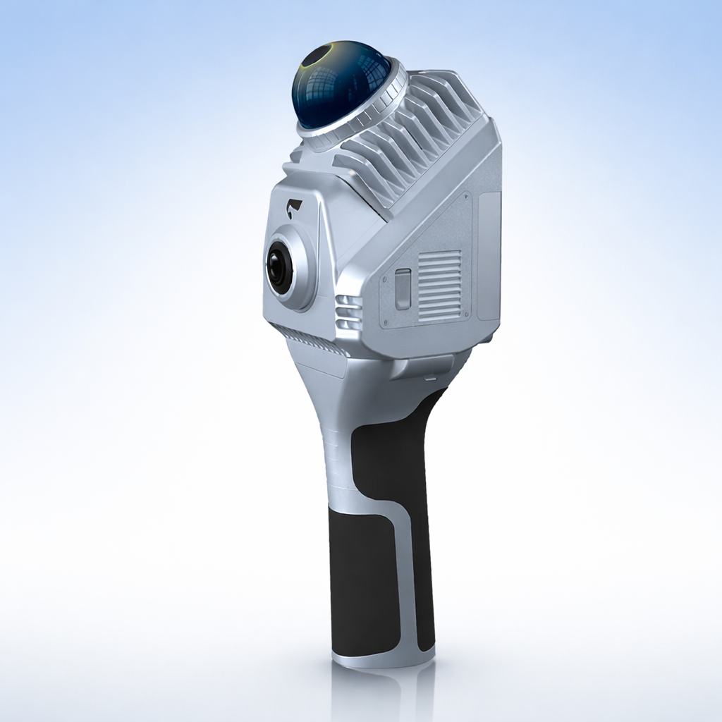
SLAM1000 Mid-Range 180° Scanner
The SLAM1000 is a compact, cost-effective handheld 3D LiDAR scanner from Feima Robotics, designed to make high-quality reality capture more accessible. Combining a non-repetitive LiDAR sensor, integrated color camera, and precision SLAM processing, the system delivers reliable, colorized point cloud data in a lightweight, easy-to-deploy form factor.
Built for straightforward handheld workflows, SLAM1000 is ideal for smaller projects, individual operators, and teams that need dependable results without the complexity of larger geospatial systems. It is especially well suited to projects where survey control is not required and the additional productivity of rotating-head or tripod-based capture workflows is unnecessary.
Typical system packages start around $6K, depending on configuration and included options.
Pricing is provided by quotation. When available, we will connect you with an authorized local dealer in your region for pricing, fulfillment, and support.
Description
SLAM1000 Scanner
The SLAM1000 is a lightweight, lower-cost handheld LiDAR scanner designed for users who need solid professional results without stepping up to a more advanced geospatial platform. It delivers high-quality point cloud data and true-color output in a compact, accessible package, making it a practical choice for smaller jobs, individual practitioners, and projects where survey control is not required and the added productivity of rotating-head or tripod-based workflows is unnecessary.
System Overview
- Real-time SLAM-based handheld scanning for fast, efficient data capture
- Lower-cost entry point into professional LiDAR reality capture
- Designed for projects where survey control and advanced geospatial workflows are not needed
- Compact, portable system well suited for smaller jobs and day-to-day scanning tasks
Why SLAM1000
- Lower system cost — an economical way to access professional LiDAR capture when the requirements do not justify a more advanced platform
- High-quality results with a simpler workflow — delivers accurate, colorized point clouds while giving up some of the flexibility and productivity offered by higher-end systems
- Best where control is not required — especially well suited to projects that do not depend on survey control or broader geospatial deliverables
- Right-sized for smaller work — a strong fit for individual operators, smaller sites, and applications where rotating-head and tripod workflows are unnecessary
Capture & Imaging
- Non-repetitive scanning laser with high-precision IMU and SLAM algorithms for reliable point cloud generation
- Integrated 12 MP camera supports true-color point cloud rendering
- Real-time point cloud acquisition during capture
- Supports external panoramic camera workflows, including emerging 3D Gaussian Splatting (3DGS) generation
Included Software & Workflow
- Includes SLAM GO (mobile) and SLAM GO POST Pro (desktop) software for complete capture-to-processing workflow
- Real-time mapping, data viewing, and browsing during field collection
- Post-processing for handheld scanner data, point cloud rendering, browsing, and colorization
- Supports panoramic image generation and 3DGS workflows with compatible accessories
- Mobile workflow supports quick measurement and industry-specific report generation
- Useful as a practical standalone solution or as supporting data within broader scanner-based projects
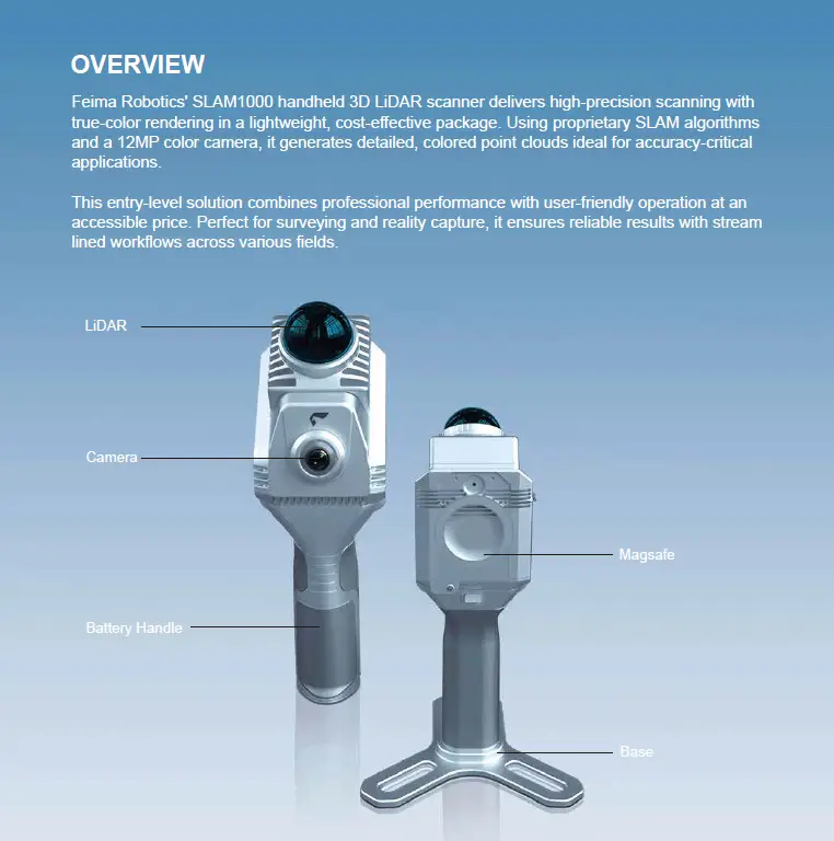
SLAM1000 Specifications
General Specifications
| Weight |
0.65 kg (Scanner)
1.16 kg (With battery and base) |
| Dimensions |
404 mm × 170 mm × 188 mm
(With battery and base) |
| Power Consumption |
18 W |
| Internal Data Storage |
512 GB SSD |
| Working Temperature |
-20 °C ~ 50 °C |
| Humidity |
< 95% |
| Protection Class |
IP54 |
| Scanning FOV |
60° (H), -7° ~ 52° (V) |
Cameras
| Camera Resolution |
12 MP |
| Camera FOV |
210° |
| Photo Resolution |
2704 × 2208 |
IMU
| Angle Random Walk (ARW) |
0.1°/√hr |
| Bias Instability |
3°/h (Allan Variance @25°C) |
Result Accuracy
| Point Cloud Thickness |
1 cm* |
| Relative Accuracy |
2 cm @ 100 m |
| Accuracy Note |
* Point cloud planar thickness within 50 m of the odometry center |
Laser
| Wavelength |
905 nm |
| Laser Class |
Class 1 |
| Range |
0.1 m ~ 70 m |
| FOV |
60° (H), -7° ~ 52° (V) |
| Laser Pulse Repetition Rate |
200 kpts/s |
| Frame Rate |
10 Hz |
Interface & Battery
| USB Type-C |
SSD data copy / Charge |
| Wi-Fi |
Supported |
| Bluetooth |
Supported |
| Battery Model |
SP30 |
| Battery Endurance |
1.7 h (single battery) |
Document Resources - Docs
Data Sheets
A quick comparison sheet for the SLAM2000 and SLAM1000 scanner models.
The official Feima Robotics SLAM1000 data sheet, covering system overview, key features, software workflow, and technical specifications.
Scanner Documents
Getting-started guidance for SLAM1000 setup, basic operation, and initial field workflow.
Detailed reference manual for SLAM1000 hardware, operation, setup, and core system functions.
Product Images and Videos
Configuration Info
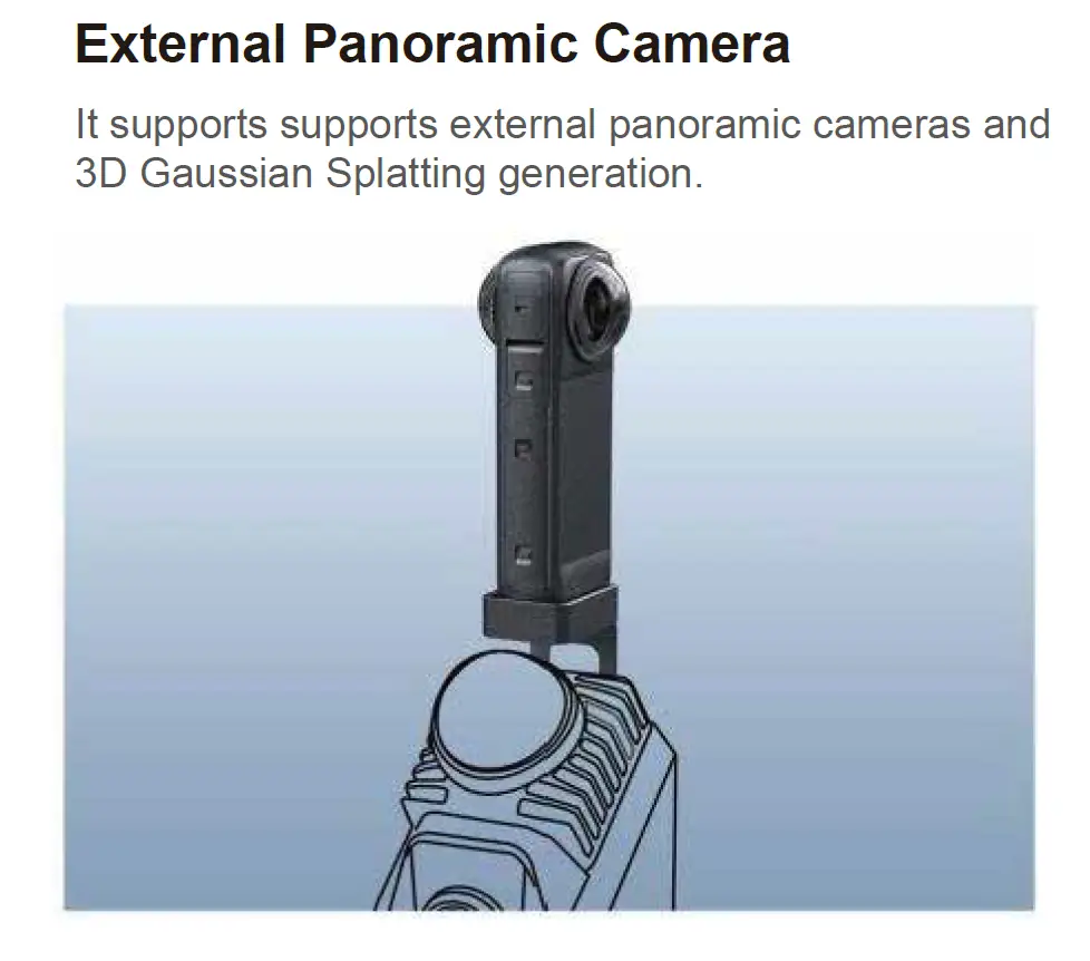
Pano Camera Attachment
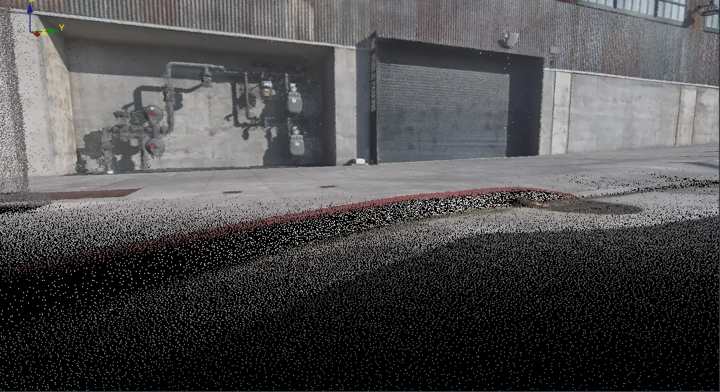
Scan Data Sample
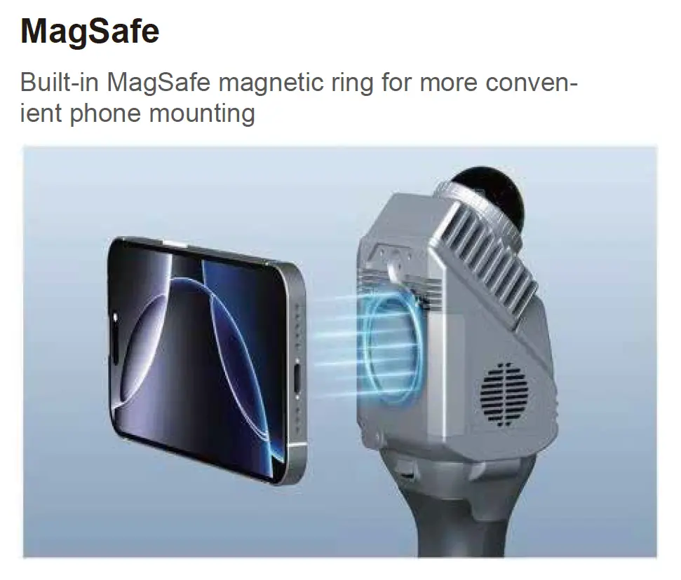
Magnetic Holder
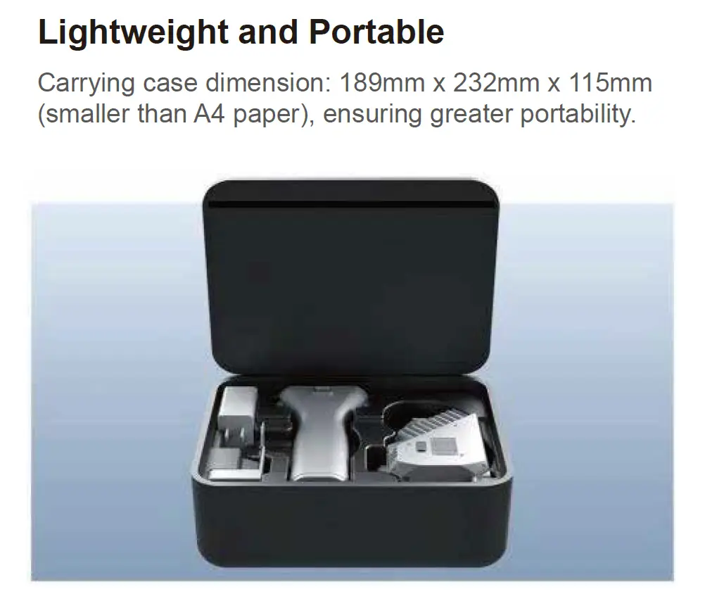
Scanner Kit
Flythrough Video
 Follow SlamScanner on LinkedIn